Status Map of Projects Along NRHT
Nov
'19 4 Next
Level Trails
Applications Submitted
on NRHT Corridor
Jly
'19 IndyGo Blue Line
& NRHT Synergy across Indianapolis
Apr '19 Preview
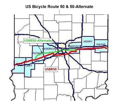
of USBR50-Alternate along NRHT
Feb '19 Several
Bike Trail Presentations Highlight
Progress & Objectives
Jan '19 Local Support Growing
for Vandalia Trail in Indy
Aug '18 Cross-State
NRHT August 2018 Update
Aug '18 People
Pathways Opens Putnam Nature Trail Phase 2
Feb '18 Progress Across
the State
Mar
'18 Monthly
NRHT, Inc. Bike Rides Planned
2024
2022-2023
2020-2021
2016-2017
2015 & before
November 2019
4 Next
Level Trails Applications
Submitted on
NRHT Corridor:
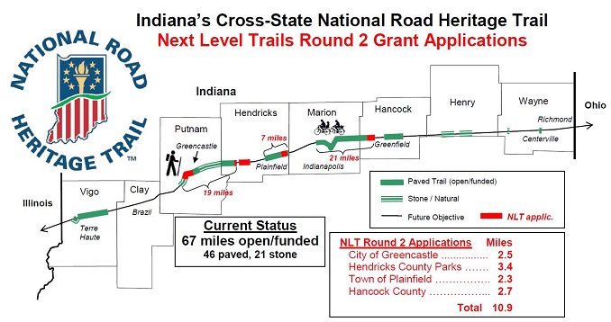
City of Greencastle 2.5 miles
Hendricks County Parks 3.4 miles
Town of Plainfield 2.3 miles
Hancock County 2.7 miles
Their locations and how they would connect or extend existing trails are shown on the map below (click on map for larger version). The State expects to complete grant awards selections by early 2020.
July 2019
IndyGo Blue Line & NRHT
Synergy across
Indianapolis:
With the NRHT bike/ped route well-established on the east side with the Pennsy Trail and connectors and the recent momentum to create the Vandalia Trail for the route on the west side, a compelling synergy with the new Blue Line Transit system is becoming very apparent. These two different modes will feed each other, providing more transportation flexibility than either would on its own. For example, for someone considering biking or walking east-west across much of the city (to work, touring, etc), knowing that there's a dependable and frequent bicycle-friendly rapid bus service easily accessible from the entire route would give that much more confidence to launch into the journey, since they would not have to worry about the potential to be stranded due to fatigue, malfunction, weather, or other unforeseen event. This group of people may not typically consider using transit, but becoming familiar with it because of their non-motorized transportation interest would increase the chances that they'd then choose to use the transit in other situations, too.
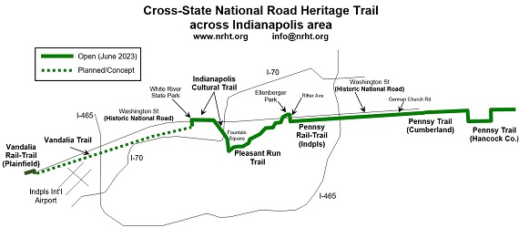
The map above shows the current status of the NRHT across Indy and where expansion is planned in the near term. It also illustrates how the new Blue Line Transit will be very accessible to most of the NRHT across Indy. Please join NRHT, Inc., the White Lick Creek & Vandalia Trail Alliance, the local City-County Councillor Jared Evans, and the growing list of supporting residents, officials, and organizations to help promote and facilitate completion of the remaining sections of the NRHT on the west side of Indianapolis. Note that Phase 1 of the Vandalia Trail to Mickley Ave will provide a trail connection from Bridgeport and Plainfield to the Blue Line Transit at High School Road and to the new multi-use trail along Washington Street.
Two upcoming activities that highlight the NRHT route in Indianapolis are the NRHT, Inc. 2019 Bike Rides (Indy) the morning of August 10 and the WLCVTA Bike/Walk event the morning of September 28.
April
2019
Preview of USBR50-Alternate
along NRHT:
February/March
2019
Several Bike Trail Presentations Highlight
Progress & Objectives:
Feb. 16 - Guest Speaker Spot: Bike Trails in Hendricks County & Indiana, hosted by Hendricks County Parks & Recreation. Greg Midgley gave a 15-slide presentation with a detailed status of bike trails in Hendricks County and a high level summary of Indiana, both including NRHT components. Greg also handed out a supplemental 1-page information sheet for Hendricks County.
Feb. 20 - Cross-State NRHT Status & Indy's Vandalia Trail presentation with the East White Lick Creek Trail Conservancy hosted at Merchants West quarterly meeting in Indianapolis.
Feb. 28 / Mar. 21 - Cross-State NRHT & Henry County, presented with Healthy Communities of Henry County at Knightstown Forward meeting & Knightstown Town Council meeting.
January 2019
Local Support Growing for
Vandalia Trail in Indy:
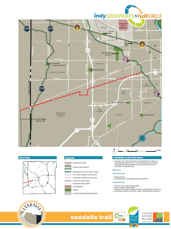
A coalition of local residents, business owners, Indianapolis City Council representatives, and trail supporters is joining together to support the development of a new segment of Vandalia Trail on the far west side of Indianapolis, to connect near the airport to Plainfield’s growing Vandalia Trail. Part of the 2014 Indy Greenways Master Plan, this trail segment would stretch 3.4 miles from the Hendricks County line to High School Road, giving pedestrians and bicyclists a safer alternative to congested U.S. 40, and laying the groundwork for the entire Indy Vandalia Trail (map below) to the Eagle Creek Trail and connection near the Hendricks County line with the future East White Lick Creek Trail.
If you’d like to see this important
quality of life project become a reality, visit the Friends
of the Vandalia Trail Facebook page for updates
and contact the Friends of the Vandalia Trail
to see how you can help.
August
2018
Cross-State NRHT August 2018 Update:
Vigo (9.9 miles) – The City of Terre Haute extended the paved sidepath along 1st Street south 2 blocks to the Historic National Road connecting with protected sidepaths already on the bridges across the Wabash River. This extends Terre Haute’s NRHT and connecting paths to 7.9 miles. In addition, the NRHT, Inc. board designated the 2-mile crushed stone Wabashiki Trail across West Terre Haute as part of the cross-state NRHT. Vigo County Parks & Recreation Department built this trail in 2012 on levees next to the DNR Wabashiki Fish & Wildlife Area. Plans for a future trail connection between these Terre Haute and West Terre Haute trails was announced this year with a mile long boardwalk along the causeway between them.
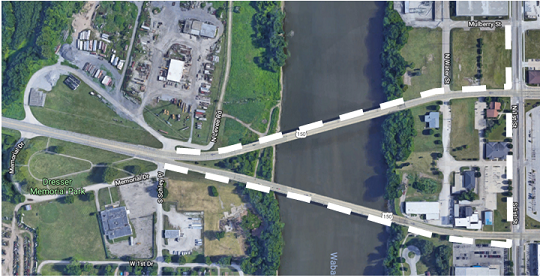
Terre Haute NRHT
sidepath extension - 0.5 miles
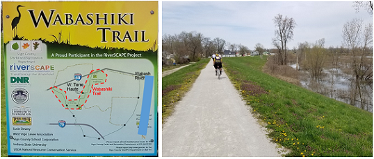
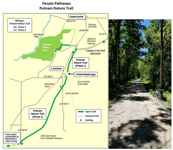
Putnam
(11.8 miles) – On August 14, the
not-for-profit People Pathways organization officially
opened the 2.6-mile smooth packed stone Phase 2 of its
Putnam Nature Trail extending southwest from Limedale,
very close to its existing 0.8-mile Phase 1 extending
southwest from Greencastle. Phase 2 includes a
well-developed trailhead at CR 150 W at the south edge
of Limedale and a nice gravel parking lot at CR 300 W
generously shared by DNR’s
Deer Creek Fish & Wildlife Area next to which
the trail runs for much of its route. In addition, the City of
Greencastle began construction of its 1-mile Phase
1 of the paved Campus Link Trail that will eventually
cross the city, connecting the Vandalia
Trail with the Putnam Nature Trail. People
Pathways continues to manage the well-established Vandalia
Trail across the eastern half of the county from
Greencastle to the Hendricks County line, connecting to
Hendricks County Parks & Recreation’s 4-mile
Vandalia Trail for a total length of 12 miles.
Hendricks
(11.1 miles) – In the past year, Hendricks
County Parks and Recreation paved the 4 miles of Vandalia
Trail that has been used as a rustic trail in the
Amo-Coatesville area since 2005. Along with major
upgrades of trailheads in both towns, this has
significantly increased the trail’s popularity with
bicyclists and pedestrians. This is part of the 12-mile Vandalia Trail open
from Amo to Greencastle. Plainfield
Parks & Recreation’s 7.2 miles of paved Vandalia
Trail and local connector trails continue to serve
as the NRHT’s cross-town route. In addition, the Town of
Plainfield Indiana has begun construction work on
its new gateway area on the north side of the Historic
National Road at the Marion County line which we
understand will include accommodation for the Vandalia
Trail along the north side of the Historic National
Road.
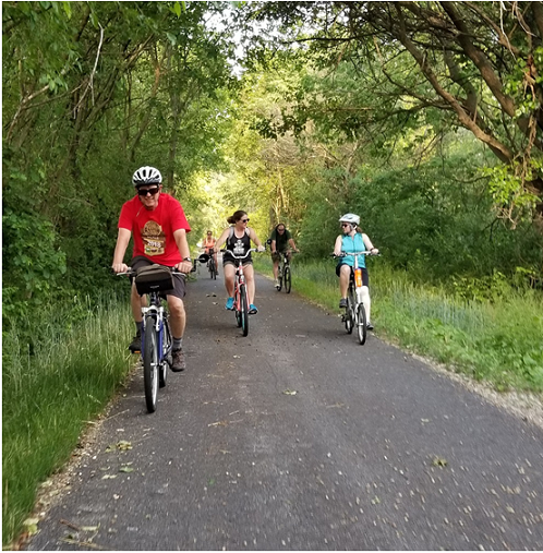
Hendricks County
Parks Vandalia Trail paved - 4.0 miles
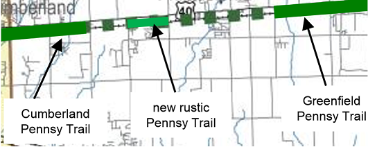
Rustic Pennsy Trail (CR 400 W - CR 500 W) - 1.0 miles
August
2018
People
Pathways Opens Putnam Nature Trail Phase 2:
Tuesday
afternoon, August 14, People Pathways formally
introduced to the community and
thanked the many partners who helped create the
2.6-mile smooth packed stone Phase 2 of the
Putnam Nature Trail extending southwest from
Limedale along the former Pennsylvania Railroad.
The event at the CR 150 W trailhead drew a large
crowd and included homemade hobo stew cooked
on-site all day, the boys and girls
track teams from South Putnam High School
inaugurating the trail with a run from the
southwest end of the trail, much happy
networking by trail builders, trail users, local
officials and trail
supporters in general, and a fun
speech by People Pathways Chairwomen Joy Marley
on the history of how this wonderful new
community amenity came to fruition and the
people and groups who were
instrumental in it. This is a great addition to
the cross-state NRHT, being one of the most
scenic segments of the overall initiative, plus
provides cyclists a direct route to bypass 3.4
miles of precarious Manhattan Road between
Greencastle and US 40.
More background on the
event and trail was described in
a Greencastle
Banner-Graphic article.
Phase 2 is not yet connected to the 0.8-mile
Phase 1 to the north that People Pathways opened
2 years ago, since these segments are currently
separated by a low-traffic active railroad line
in Limedale. Work is on-going to negotiate a
future crossing.
February 2018
Progress Across the State:
Many trail projects
along the cross-state National Road Heritage
Trail initiative are currently adding or
upgrading miles. This Spring, People
Pathways will open 2 more miles of the Putnam Nature Trail (Phase
2) with a crushed stone surface southwest
of Greencastle. The city of
Greencastle has begun clearing the route
for its next 1-mile phase of the paved
Campus Link Trail that will
eventually extend across the entire city
parallel to Veterans
Memorial Highway. Hendricks
County Parks & Recreation is near
completion of its upgrade of 4.5 miles
of the rustic Vandalia Trail to
paved. Indianapolis
Parks & Recreation is in the
acquisition process of Pennsy corridor in the trail
gap between Irvington and
Cumberland, with plans to add some
construction in 2019 as well as
upgrade several sections of
Pleasant Run Trail that
year. The volunteer
group Pennsy Trails of Hancock
County has completed acquisition of
1-mile of Pennsy corridor in the
trail gap between Cumberland and
Greenfield and plans to open it as a
rustic trail in 2018, then upgrade
it with an awarded
TAP grant within 2 years. Also in Hancock
County, a consortium of 7
municipalities, Pennsy Trails of
Hancock
County, the Hancock
County Community
Foundation, and Hancock
Regional Health launched
in the past year creation
of a formal
countywide trail
plan intended
to connect all
communities in the
county.
March 2018
Monthly NRHT, Inc. Bike Rides Planned:
NRHT, Inc. has planned
a series of free monthly bike rides to explore
the open sections of the cross-state National
Road Heritage Trail and to enjoy the local
culture of each area. Below are the dates that
are set this Spring and summer and
the maximum mileages. The out and
back routes allow riders to choose
shorter distances and still ride
with the group. Most rides will include 2 trails
connected by on-road sections of U.S. Bike Route
50 or proposed 50A. Individual
announcements will be made for each ride giving
starting times and locations and more details on
the surface types, etc.
For a preview, visit the NRHT
maps page.
April
21 - Terre Haute/Vigo County (NRHT,
ISU trails, Wabashiki Trail) [22 miles]
May 12 -
Indianapolis (Pennsy Trail,
Pleasant Run Trail, Indpls Cultural
Trail, White River Trail, Eagle Creek
Trail) [32 miles]
June
16 - Hendricks County (Plainfield
& Hendricks County Vandalia Trails) [45
miles]
July
14 - Hancock County
(Greenfield & Cumberland Pennsy Trails, Buck
Creek Trail) [32 miles]
Aug
11 - Henry County (Raysville &
Lewisville NRHTs) [19 miles]
Sep 22 - Putnam County (People Pathways, Vandalia Trail, Putnam Nature Trail) [30 miles]


